A House In A Field
The story of a house. In a field. And how it gets there.
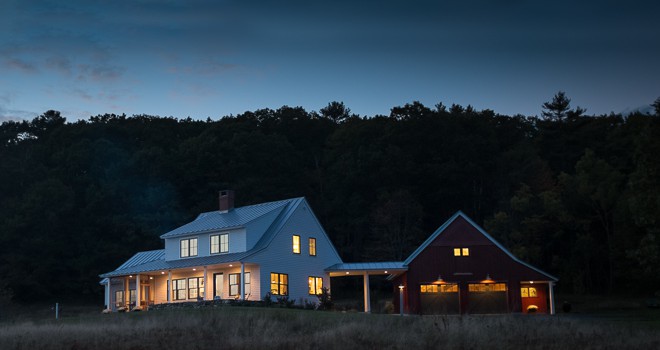
This is the episode where they show all the old clips.
 We’ve made a pinky-swear to do a “catch up” post before big milestone events :
- Barring something unforeseen, work starts on the driveway on Monday. (That would be the “milestone” event driving this update.) We decided on the Karen route.
- After numerous failed attempts, the town of Freeport has finally issued us “7 Dash Landing” as our new address.
- The long sordid saga of electricity is heating back up. Fairpoint/Verizon is now “sending an engineer” which we’re sure is the same as “the check is in the mail.”
- We’ve reviewed the 2nd round of plans with potential contractors. Given how quickly things are coming together, Rob thought it might be helpful to get their perspective early in process. Let them ask questions, get input, find out where we need more information, etc.
- We brought our friend Mr. Septic System designer onto the site before we purchased it, but now that the house is staked out, he’s in the process of designing the final system. The new dirt that he’s found is apparently much nicer than the old dirt that he found. Which is apparently good.
- We’re working with a Land Planner to develop both a short-term and long-term plan for the property. We’ve already received four calls/inquiries about the Cove Road lot and it seemed smart to put it into a bigger context.
- We’re on Round 3 of plans with Rob. I’ll call this the “finesse” stage — it’s about little changes to make the house more livable. Are the kitchen cabinets in the right spots? Where will the dishes and plates go? (Grapefruit spoons too.) What are the counters made of? Where will we store the lawnmower? Where does the workshop go?
- One of the biggest discussions lately has been about the HVAC system. HRV vs. ERV. Propane vs. wood pellets vs. heating oil. Radiant vs. forced air vs. baseboard. Tylenol vs. Advil. Our goals for the house are to minimize our footprint and limit financial exposure to heating bills in the future, but “simplicity” can’t be overlooked.
Things are definitely moving along.
Dig Safe
Looks like we’ve had a visit from the Dig Safe fairies.
Can’t see it in this photo, but the writing essentially reads “no electricity, no gas, no water, no sewer.”
Yes — that just about covers it.


Different Dash. Way different.
 It’s official. It took seven tries, but the white smoke rose gracefully out of the Freeport Town Hall today. Our new address will be* :
7 Dash Landing
The “7” is just a wonderful coincidence. The “Dash” was a privateer ship that was built at Porter’s Landing by a James Brewer. And since our deed mentions the transfer of the field from George Bartol to Daniel Brewer in 1855, we liked the historical connection. (Daniel Brewer was also a ship builder) There’s a lot more about the “Dash” here.
All hunky-dory, right? A little bit of local history and a fun play on words. Toss in a reminder of the hassle of naming this thing and a well respected “lucky” number and it’s just about perfect.
That balloon got burst about five minutes later when someone at the office asked “Why did you name your driveway after the Kardashian’s chain of stores?”
That’s right, the Kardashians….
(* Please note the “will be.” At this point, there’s no driveway, there’s no mailbox, no power, no house. There’s string and sticks in a field. We’ll let you know when that changes.)
“It’s amazing what you can do with an E in A-level art, twisted imagination and a chainsaw.” – Damien Hirst
Last week’s meeting involved a certain amount of house “repositioning” at the site. The plan has a few tweaks and we wanted to see how they looked. We’ve also grown to appreciate the long view of the Harraseeket River from the field and wanted make sure the house made the most of it.
Lots of stake moving and string. Swearing. Imagine knitting with four foot long wooden poles while wearing mittens.
And despite our best efforts, we couldn’t position the house so that our living spaces got that view. Fantastic from the garage walkway. Not so good from the porch or the bedroom. The primary culprit? A large bushy pine tree down at the end of the field.
The remaining dialog went along these lines :
“Do you own that part of the field?”
Yes.
“Is it in the wetlands zone?
No.
“Do you like the tree?
No.
“Do you own a chainsaw?”
That afternoon, Deb stopped by the Town Office and double-checked. Not only are we “A-OK” to take it down, but the general consensus seems to be that a chainsaw might be the best thing for all of Freeport.

First Set of Plans
Here’s the first set of drawings. We’ve made tremendous progress over the last couple of weeks, but it’s amazing how little the core design concept has changed since this first review meeting in early October.
Before jumping in, it’s worth remembering a few of our goals :
- We want a house that “fits” into the Porter’s Landing neighborhood without looking forced.
- Part of that relates to scale. We’ve targeted 2,500 square feet. That’s proven to be one of the more “controversial” aspects of the project. We just think it’ll live more comfortably, be easier to maintain, easier to heat and a testament to Steve’s remarkable cheapness for everything without a Nikon label.
- First floor living. Sure, go ahead and laugh. But after a few years in our Sugarloaf place, we’ve come to appreciate the value of having everything on the first floor.
More of the “Wishlist” is linked to the right. (And we’ll just add that the time & energy spent on this list has proven invaluable.)
A few things to look for in this first set of drawings :
- All of our important living space is “south facing.” Bathrooms, mudroom, closets are on the north side.
- We wanted to be able to see the driveway from the kitchen
- A distinct entrance. No one is ever quite sure which door to use here on Flying Point. Front door? Through the gate to the more visible back door? Through the garage?
- The ability to “close off” the mud room from the rest of the entry.
- The office (aka “Flyingpointroad.com World HQ”) that separates the master bedroom and living space.
- The stone terrace. No more decks. And given that we’re at Sugarloaf for the major winter holidays, it’s more likely that our Freeport entertaining happens in the Spring and Summer. This space “stretches” our house.
- The 2nd floor might be “simple,” but both rooms are south facing and have windows on two walls. Which is nice.
Let us know what you think.


Seriously, who’s making these decisions?
Names rejected by Town Hall yesterday :
- “Bartol Field Way”
- “Porter’s Field Way”
Names rejected this morning :
- “Farm House Way”
- “King’s Landing”
Names rejected this afternoon :
- “Extra Blue Way” (There’s nothing even remotely close to this name in Freeport. It’s a Swix ski wax. Our guess is that they’re worried about manic depressives taking over the neighborhood.)
- “River’s End”
This might be the hardest part…
 We’ve now been presented with what might go down as this project’s biggest challenge.
What do we name the driveway?
It’s a fairly simple process. The town gave us a list of current street names and we’re to submit our first three choices. They’ll then review them with Public Safety and let us know.
Our first choice was obvious. Given that the project’s working name has been “Bartol Field,” we quickly submitted “Bartol Field Way.” Not only is it a nice name, but there’s significant historical context. According to survey records, the field was sold by George Bartol to Daniel Brewer in 1855 and we thought that the connection to town history was a nice touch.
Rejected. Too close to another name in town.
OK. Let’s try another historical angle. The field is the most prominent feature of Porter’s Landing. How about “Porter’s Field Way?”
Gong. Again too close to another name in town.
We’ve now turned to Facebook. Names submitted to date and in no particular order :
- “Toko Jonesy Lane”
- “Great Picture Lane”
- “Andies Avenue”
- “Bobcat Boulevard”
- “Golden Years Road”
- “Marital Bliss Lane”
- “Harm’s Way”
- “Bateau Drive”
- “Skinny Ski Lane”
- “Cross Country Court”
- “Something About A Donkey”
- “Spruce Lane”
- “Loafer Road”
- “Gondola Height”
- “Fuller Lane”
- “Fullofit Road”
- “Liverjay Road”
- “Bean’s Way”
- “Deer Field Way”
- “Full Sail Drive”
- “Fox Hollow”
- “Abby Road” (No “e”)
- “Bean Down That Road”
- “Highway to Hell”
- “Thunder Road”
- “Mr Bean Drive”
- “Nordic Knoll”
- “Fullerton Road”
- “Boat n Tote Lane”
- “Atlasta Road”
- “Bobcat Way”
- “Kick Turnpike”
- “Fuller Boulevard”
- “Meme Street”
- “F-stop Road”
- “Focal Length Way”
- “Farm Field Way”
- “King’s Landing”
- “Dash Drive”
- “Nordic Field Way”
- “Toko Field Way”
- “Field Way”
- “Livermore Way”
- “Harraseeket Field Way”
- “Kennebec South Way”
Your submissions are welcome and encouraged. No name = No Driveway. No Driveway = No Electricity. “No Electricity = No House.”
Step up and be counted.
Today we talked about North Jay Granite.
All we can say is “wow.”
This project started with a lot of handwringing and teeth gnashing about a start date. A builder package that starts in the fall? Work with an architect and hope for a spring date?
And “hope” was truly the operative word with the second option. One house designer/lover of the outdoors told us that it would be at least a year before we’d be ready to start talking to builders. And when you start thinking about a year of architectural services at an hourly rate….well, it’s not something that decent people should have to contemplate. (No offense to all you architects/house designers/lovers of the outdoors out there.)
So it’s nothing short of amazing to say that today’s meeting — just four weeks into the project — included a near-final floor plan and our first set of exterior elevations. Between our initial pre-work and Rob’s enthusiasm, the project is flying along.
We’ll start to post some of the drawings over the next few days. In the meantime, here are the initial site details. Given that we pulled permits for the driveway today, it seems right to start here.
Pretty straightforward. You’ll note that we’ve been surprised by the amount of pitch/slope in that part of the field. And if you look at the back corner of the house sketch, you’ll see that we’re already making plans on how to best divert that water around the foundation.
And yes, we really did talk about North Jay Granite. We’re thinking stoops.

“Adventure is just bad planning” – Roald Amundsen
At the advice of a boatload of people (we’re sticking with the Amundsen theme), we met with a Land Planner this week.
We think our goals for Bartol Field have been fairly consistent from the beginning : Find a nice spot for a new house, protect as much of the parcel as possible and not go bankrupt. But the details involved in achieving those objectives — and all of those objectives — have been more complex than anticipated. Tree Farm opportunities. Open Space tax benefits. Abutter sales. Five-year breakouts. Watersheds. Toss in the fact that we’re already getting inquiries about a possible Cove Road lot and it was clear that we needed some help.
It was definitely time well spent. In the course of about two hours, we had quickly roughed out both a short-term and long-term approach to managing the property. And while much of it was consistent with our early “uninformed” opinions, the notion of using building envelopes to manage sight lines and privacy was a welcome new notion.
There’s no doubt that this project is already starting to take on the warm patina of a well-used ATM machine. But we can’t help but think that these week’s withdrawal was money well spent.

Karen, Karl or Darrell?
This week’s adventure involves the driveway. Deb met with four different contractors to get their thoughts (and estimates) over the last five days to determine the best route from Point A. to Point B.
As you know, the Town of Freeport graciously located Point A. for us. Lower Mast Landing has a couple of blind knolls and they’d like the driveway to start safely between them. Rob picked out Point B. It exits the woods at the top of field next to a gorgeous oak tree and slowly reveals the house.
It’s the 375′ connecting those two points that makes this an interesting exercise. There’s a surprising amount of elevation between the road and the house lot. Complicating matters is that this gain starts quickly from the road (The red “X” on the illustration.)
The initial thought was to go right. Let’s call that the “Darrell” route. We’ll start with 12′ of flat space and have the road make a slow arc to the right, climbing around the hill and then following the natural ridge line up towards the house.
The good news is that it’s the most gradual approach and there’s a beautiful ravine off to the right. The bad news? There’s a ravine off to right. And making that turn coming down the hill in the winter time might require nerves of steel.
The excavators have been mixed on “Darrell.” Definitely possible from an excavation perspective and the most aesthetic of the options . One of the contractors also thought that boulders and trees could be placed along the ravine line to minimize risk. At the same time, another contractor pointed out that the right side — especially after we excavate the side hill to create the road — will be in the shade.
That brings us to “Karen.” (The blue route on the map) We’d start with the same 12′ flat spot, but this time we’d go to the left. A touch steeper as it crests the hill, but without the sweeping turn — more of a “wiggle.” Once up over the hill, it would move to the center and follow “Darrell’s” route to the house. Maybe not quite as beautiful, but a bit shorter and definitely less expensive. And as an added bonus, we’d be on the “light” side of the hill and a large part of the driveway would get afternoon sun. One of the contractors also thought that it had less chance of washouts.
Finally, today’s excavator introduced us to the idea of “Karl.” Straight up over the hill. That’s why God invented bulldozers. Could be exciting in the winter, but that’s why Allah invented four-wheel drives.
Rob, Deb and I need to have a couple of discussions before making a decision. The good news is that no one is particular invested in “Darrell,” “Karl” or “Karen.”
We’re just looking for the best way between Points A. and B.
